UAV Systems Engineering · M5-L6 · Guided lab
Plan a path in a 3-D voxel map
Implement the planner of lesson M5-T17 yourself, then use it to answer a design question: how big can the vehicle be?
What you will do
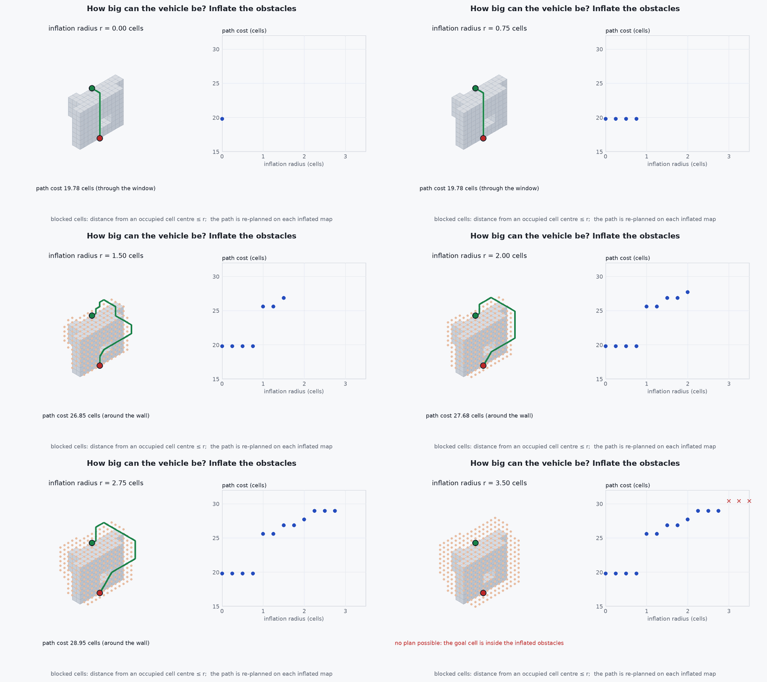
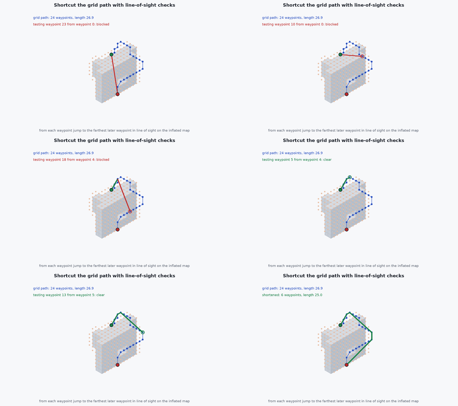
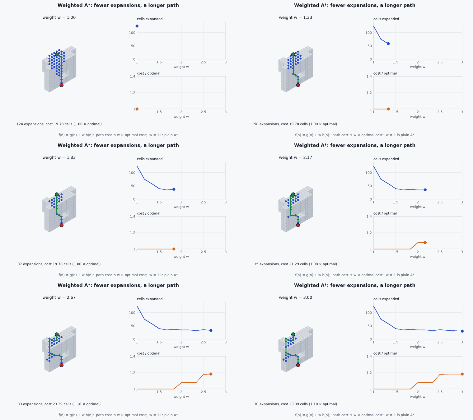
You will implement a planner for a small 3-D voxel map: a low wall to fly over or around, a full-height wall with a window, and a pillar. You will write the 3-D octile heuristic, the obstacle inflation, A* with a weight, and a line-of-sight shortcut. Then you will use the planner to measure how the path and the search effort change with the weight and with the vehicle size, and to find the largest inflation radius at which a path still exists.
The map and the numbers are illustrative; they are chosen so that every experiment runs in well under a second.
Before you start
- Lesson M5-T17 (3-D path planning on voxel maps) and, for the search, lesson M5-T11 (A* and RRT path planning).
- Python 3 with NumPy.
Starter
import heapq, math
import numpy as np

def make_world():
    occ = np.zeros((16, 16, 8), bool)
    occ[5:7, 0:11, 0:5] = True          # low wall: over it (z >= 5) or around it (y >= 11)
    occ[10:12, 5:16, :] = True          # full-height wall ...
    occ[10:12, 8:11, 2:4] = False       # ... with a window (y 8..10, z 2..3)
    occ[3:5, 8:10, 0:4] = True          # pillar
    return occ

N26 = [(i, j, k) for i in (-1, 0, 1) for j in (-1, 0, 1) for k in (-1, 0, 1) if (i, j, k) != (0, 0, 0)]
occ = make_world(); start, goal = (1, 2, 1), (14, 13, 2)

def h_oct3(a, b):
    # TODO 1: the 3-D octile distance. Sort the absolute offsets d1 <= d2 <= d3 and combine them with the costs 1, sqrt(2), sqrt(3)
    raise NotImplementedError

def inflate(occ, r):
    # TODO 2: return a copy of occ in which every cell whose centre is within r cells of an occupied cell is also blocked
    raise NotImplementedError

def astar(occ, s, g, w=1.0):
    # TODO 3: A* on the 26-connected grid with step cost = Euclidean length of the move and f = g + w * h.
    #         Return (path as a list of cells, cost, number of expanded cells). w = 0 gives Dijkstra's algorithm.
    raise NotImplementedError

def shortcut(occ, path):
    # TODO 4: from each waypoint jump to the farthest later waypoint that is still in line of sight (sample the segment every 0.25 cells)
raise NotImplementedErrorReference solution
Show the solution (try first)
import heapq, math
import numpy as np

def make_world():
    occ = np.zeros((16, 16, 8), bool)
    occ[5:7, 0:11, 0:5] = True          # low wall: over it (z >= 5) or around it (y >= 11)
    occ[10:12, 5:16, :] = True          # full-height wall ...
    occ[10:12, 8:11, 2:4] = False       # ... with a window (y 8..10, z 2..3)
    occ[3:5, 8:10, 0:4] = True          # pillar
    return occ

N26 = [(i, j, k) for i in (-1, 0, 1) for j in (-1, 0, 1) for k in (-1, 0, 1) if (i, j, k) != (0, 0, 0)]

def h_oct3(a, b):
    d = sorted(abs(a[i] - b[i]) for i in range(3))
    return (math.sqrt(3) - math.sqrt(2)) * d[0] + (math.sqrt(2) - 1) * d[1] + d[2]

def inflate(occ, r):
    """Block every cell whose centre is within r cells of an occupied cell."""
    pts = np.argwhere(occ); out = occ.copy(); idx = np.argwhere(np.ones_like(occ))
    for c in pts:
        out[tuple(idx[np.linalg.norm(idx - c, axis=1) <= r].T)] = True
    return out

def astar(occ, s, g, w=1.0, climb=1.0):
    """Weighted A*: f = g + w h. `climb` multiplies the cost of the vertical part of a move (1 = no penalty)."""
    if occ[s] or occ[g]: return None, None, 0
    openq = [(w * h_oct3(s, g), 0.0, s)]; gs = {s: 0.0}; parent = {s: None}; closed = set()
    while openq:
        _, gc, u = heapq.heappop(openq)
        if u in closed: continue
        closed.add(u)
        if u == g: break
        for d in N26:
            v = (u[0] + d[0], u[1] + d[1], u[2] + d[2])
            if not all(0 <= v[i] < occ.shape[i] for i in range(3)) or occ[v] or v in closed: continue
            ng = gc + math.sqrt(d[0] ** 2 + d[1] ** 2 + (climb * d[2]) ** 2)
            if ng < gs.get(v, 1e18): gs[v] = ng; parent[v] = u; heapq.heappush(openq, (ng + w * h_oct3(v, g), ng, v))
    if g not in parent: return None, None, len(closed)
    path = []; u = g
    while u is not None: path.append(u); u = parent[u]
    return path[::-1], gs[g], len(closed)

def clear_segment(occ, a, b, step=0.25):
    a, b = np.array(a, float) + 0.5, np.array(b, float) + 0.5; n = max(1, int(np.linalg.norm(b - a) / step))
    return all(not occ[tuple(np.floor(a + (b - a) * t / n).astype(int))] for t in range(n + 1))

def shortcut(occ, path):
    out = [path[0]]; i = 0
    while i < len(path) - 1:
        j = len(path) - 1
        while j > i + 1 and not clear_segment(occ, path[i], path[j]): j -= 1
        out.append(path[j]); i = j
    return out

length = lambda pts: sum(math.dist(pts[i], pts[i + 1]) for i in range(len(pts) - 1))
occ = make_world(); s, g = (1, 2, 1), (14, 13, 2)

# 1. the optimal path and what the heuristic saves
path, cost, n_a = astar(occ, s, g); _, cost_d, n_d = astar(occ, s, g, w=0.0)       # w = 0 is Dijkstra
print(f"A*: cost {cost:.2f}, {n_a} expansions; Dijkstra: cost {cost_d:.2f}, {n_d} expansions")
assert abs(cost - cost_d) < 1e-9 and n_a < n_d / 5

# 2. weighted A*: fewer expansions, cost within w times optimal
rows = []
for w in (1.0, 1.5, 2.0, 3.0):
    _, c, n = astar(occ, s, g, w=w); rows.append((w, n, c)); print(f"w = {w}: {n:4d} expansions, cost {c:.2f} ({c / cost:.2f} x optimal)")
assert all(c <= w * cost + 1e-9 for w, n, c in rows) and rows[-1][1] <= rows[0][1]

# 3. how large can the vehicle be? sweep the inflation radius
last_ok = None
for r in (0.0, 0.5, 1.0, 1.5, 2.0, 2.5, 3.0, 4.0):
    p, c, _ = astar(inflate(occ, r), s, g)
    print(f"inflation {r:3.1f} cells: " + (f"cost {c:.2f}" if p else "no path"))
    if p: last_ok = r
assert last_ok is not None and 1.5 <= last_ok < 4.0                    # some route exists up to a radius of at least 1.5 cells, and none at 4

# 4. shortcut on the inflated map keeps the clearance
occ_i = inflate(occ, 1.5); pi, ci, _ = astar(occ_i, s, g); sc = shortcut(occ_i, pi)
print(f"waypoints {len(pi)} -> {len(sc)}, length {length(pi):.2f} -> {length(sc):.2f} cells")
assert len(sc) < len(pi) and all(clear_segment(occ_i, sc[i], sc[i + 1]) for i in range(len(sc) - 1))

# 5. a penalty on vertical motion: less climbing, possibly a longer path
climb_total = lambda p: sum(max(0, p[i + 1][2] - p[i][2]) for i in range(len(p) - 1))
pc, cc, _ = astar(occ, s, g, climb=3.0)
print(f"climb: {climb_total(path)} cells -> {climb_total(pc)} cells with a vertical penalty of 3")
assert climb_total(pc) <= climb_total(path)Experiments
- Check that the path is collision-free and that its cost never falls below the straight-line distance between start and goal.
- Tabulate expansions and path cost for , 1.5, 2, 3. At which does the cost first exceed the optimal one, and is it always within times the optimum?
- Sweep the inflation radius in steps of 0.25 cells between 2.5 and 3.0 and find the largest radius that still has a path. Convert it to metres for a cell size of 0.2 m and compare with a vehicle of 0.35 m radius plus a 0.1 m margin and the half-diagonal of a cell.
- Plot the unshortened and shortened paths in a 3-D scatter plot (matplotlib) and mark the window. On the raw map the path flies through the window; find the smallest inflation radius at which it stops using the window, and check that the shortened path on the inflated map stays clear of every wall.
- Double the resolution (repeat every voxel twice along each axis, and double the start and goal coordinates) and compare the number of expansions with the factor of eight in cells.
How to know it worked
- The starter functions are implemented and the solution’s assertions pass for your version.
- A* and Dijkstra give the same path cost and A* expands far fewer cells.
- You have a table of expansions and cost against the weight, and the largest inflation radius with a path.
- The shortened path is clear on the inflated map and has fewer waypoints.
If it does not work
| Symptom | Likely cause | What to check |
|---|---|---|
| A* returns a longer path than Dijkstra | The heuristic overestimates (for example the 2-D octile distance applied to three axes, or the wrong sort order of the offsets) | Test on random neighbours, and check that equals the true cost on an empty map |
| No path appears after inflation | The start or goal lies inside the inflated obstacles, or the only route was closed by the inflation | Print which cells are blocked near the start and the goal and reduce the radius, or move them |
| The shortcut path touches the wall | The line-of-sight check used the raw map, or the sampling step is too coarse | Check on the inflated map and sample every quarter of a cell or finer |
| Planning is slow | Neighbours are generated with Python loops over a large map | Limit the search to a local window, use a coarser map, or raise the weight |
References
Record your progress
Saved in this browser. This lab runs on your own machine, so the site cannot check it for you.