UAV Systems Engineering · Module 4
M4-T14: Mapless versus map-based navigation
Map-based navigation buys a drift-free reference at the price of preparation and change; mapless navigation is free to start and pays in accumulating error.
Whether to map in advance is a systems decision, not an algorithm choice. It is settled by two numbers: how far the vehicle can fly before drift exceeds the clearance, and how much the environment changes between mapping and flying.
Learning objectives
After this lesson, you should be able to:
- Define mapless (odometry and local mapping) and map-based (prior global map) navigation.
- Compute the distance a drifting estimator can fly before exceeding a clearance requirement.
- Compare preparation cost, robustness to change and failure behaviour.
- Design a hybrid: odometry with periodic map or landmark corrections.
Conceptual explanation
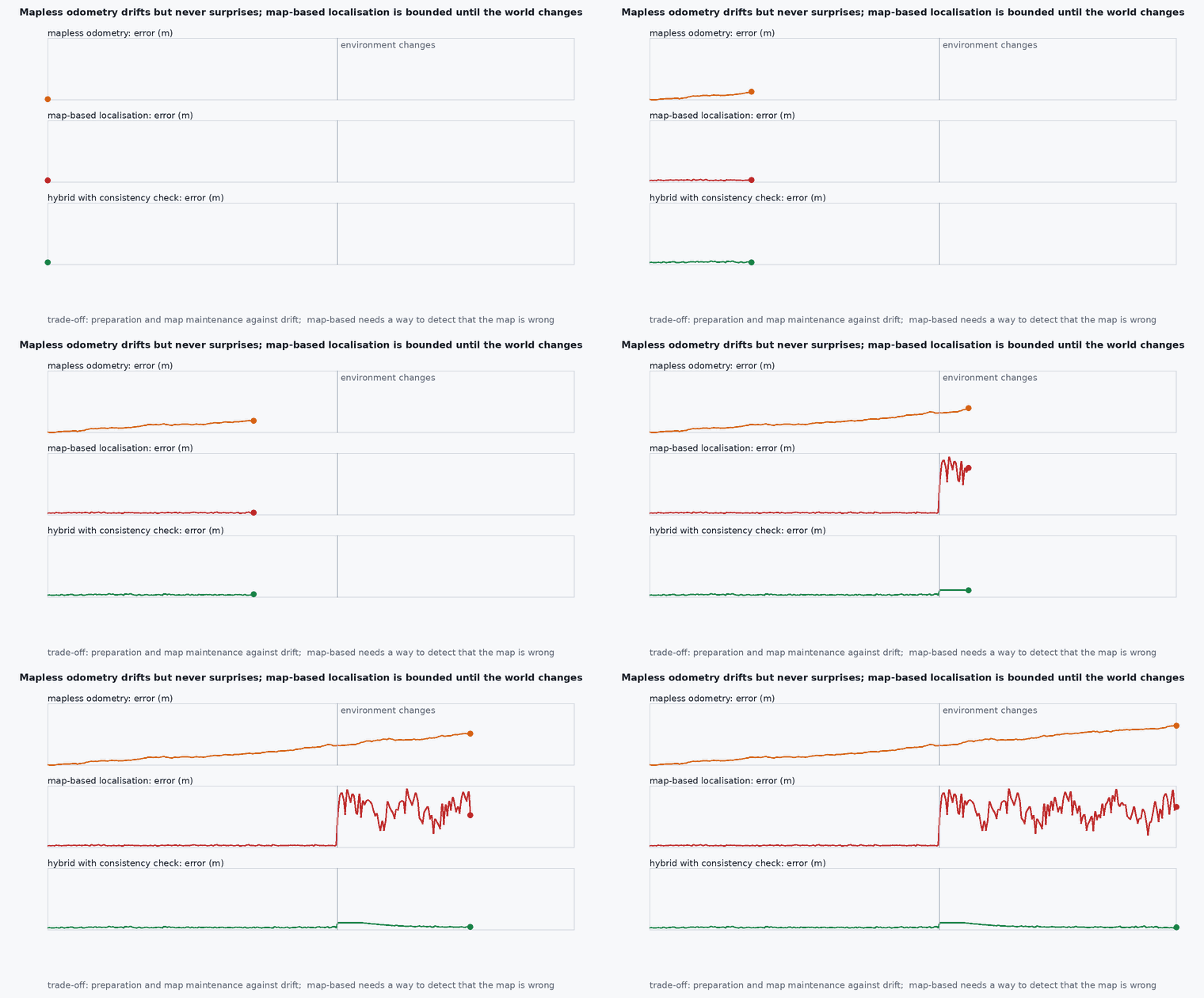
Mapless navigation relies on odometry (VIO, LIO) and a local map built on the fly for obstacle avoidance; position is relative to the start and drifts. Map-based navigation localises against a prior global map built in an earlier flight or survey, so the position error is bounded by the map accuracy and the localisation, not by distance flown. Hybrid systems use odometry between map-based corrections.
Engineering intuition
A one percent drift is nothing over 20 m and 3 m over 300 m. If the corridor to the work area is 50 m and the clearance is 1 m, mapless is fine; if the vehicle must return along a 1 km route within 0.5 m, drift alone will not do. A prior map replaces drift with a bounded localisation error, but only while the map matches the world: after furniture is moved or a door opens, the map-to-sensor agreement degrades and localisation can fail abruptly rather than gradually. Odometry degrades smoothly; map-based localisation can fail suddenly.
Mathematical formulation
Drift budget: with drift ratio (error per distance travelled) and a position requirement (the clearance divided by a safety factor ), the maximum distance without a correction is:
With corrections every metres (landmarks, map matches) that reset the error to , the worst-case error is ; choose such that it stays below the requirement. Map change: if a fraction of the map points have changed, the registration inlier ratio falls roughly as 1 − ; localisation needs a minimum inlier ratio (for example 0.3–0.5, depends on the method) to converge.
- drift ratio ( of error per travelled).
- ,
- clearance and number of standard deviations to cover.
- distance between corrections.
Architecture and data flow
Preparation workflow for map-based flight: map flight, cleaning (remove dynamic objects), accuracy evaluation (lesson M4 labs), versioning under configuration control (lesson M7-T19), then a localiser with a confidence output (lesson M4-T15) feeding the navigation manager. Mapless: local map for avoidance only, with return-to-home by retracing the odometry path while drift allows.
Real-world UAV applications
- Repeated inspection of a plant: map-based.
- Exploration of an unknown tunnel: mapless with retrace.
- Delivery between two known sites: map-based or hybrid.
- Search and rescue: mapless with opportunistic loop closure.
Implementation example
This runs as shown: a small decision model computing the drift budget, the required correction spacing, and the verdict (mapless, hybrid, map-based) for several missions, with map-change tolerance.
from dataclasses import dataclass

@dataclass
class Mission:
    name: str; route_m: float; clearance_m: float; drift_ratio: float; env_change_fraction: float; reference_known: bool

def decide(m: Mission, k=3.0, min_inlier=0.5):
    e_req = m.clearance_m / k; d_max = e_req / m.drift_ratio
    if m.route_m <= d_max: return "mapless", d_max
    spacing = d_max * 0.8                                            # corrections must come before the budget is used up
    inlier = 1.0 - m.env_change_fraction
    if m.reference_known and inlier >= min_inlier: return ("map-based" if m.route_m > 5 * d_max else "hybrid"), spacing
    return "needs another reference (landmarks, GNSS, shorter route)", spacing

cases = [Mission("tunnel inspection, 40 m", 40, 2.0, 0.01, 0.0, False), Mission("warehouse patrol, 100 m, stable", 100, 1.0, 0.01, 0.1, True),
         Mission("campus route, 2 km, stable map", 2000, 2.0, 0.01, 0.2, True), Mission("changed site, 400 m", 400, 1.0, 0.01, 0.6, True), Mission("unknown cave, 500 m", 500, 1.0, 0.01, 0.0, False)]
out = {m.name: decide(m) for m in cases}
for k, (v, d) in out.items(): print(f"{k:34s} -> {v} (correction spacing / budget {d:.0f} m)")
assert out["tunnel inspection, 40 m"][0] == "mapless" and out["warehouse patrol, 100 m, stable"][0] == "hybrid" and out["campus route, 2 km, stable map"][0] == "map-based"
assert out["changed site, 400 m"][0].startswith("needs") and out["unknown cave, 500 m"][0].startswith("needs")
assert abs(decide(cases[1])[1] - 0.8 * (1.0 / 3.0) / 0.01) < 1e-9Common engineering mistakes
Choosing a prior map for convenience without a change budget
A stale map fails abruptly.
Assuming drift is linear in all environments
It depends on the scene: corridors, darkness and vibration change it.
Mapping with different sensors than those flown
Registration of different modalities is brittle.
No map versioning
The vehicle flies against an unknown map revision.
No fallback when localisation fails
The navigation manager needs a degraded mode (lesson M8-T10).
Failure modes
| Failure mode | How it shows up | Likely cause |
|---|---|---|
| Abrupt localisation loss | Pose jumps or freezes after a layout change | Map outdated |
| Drift beyond clearance | Contact near the end of a long route | Mapless over too long a route |
| Wrong map version | Systematic offset | No configuration control |
| Slow relocalisation | Long hover after loss | Poor initial pose or ambiguity |
Debugging approach
- Measure drift ratio on representative routes, not on a benchmark.
- Monitor localisation confidence over a flight.
- Compare the map with a fresh scan before the mission.
- Test the fallback by forcing localisation loss.
Practical exercises
- Compute for , , %.
- Design correction spacing for a 1 km route with 0.5 m requirement and 1% drift.
- Define what “environment changed” means as a pre-flight check.
- Propose a hybrid design using floor markers every 30 m.
Interview questions
Write an answer in your own words, then reveal the model answer. Nothing is sent anywhere.
Question 1
When is mapless navigation enough?
Model answer
When the route length times the drift ratio stays under the position requirement (clearance divided by a safety factor).
Question 2
What is the main risk of map-based navigation?
Model answer
Abrupt failure when the environment differs from the map, because localisation depends on matching and has no gradual degradation.
Question 3
What is a hybrid design?
Model answer
Odometry between periodic absolute corrections from a map, landmarks or GNSS, with correction spacing set by the drift budget.
References and further reading
Primary papers, official documentation and standards. Each claim above that is specific to a tool or version points here.
- . . Groves, Principles of GNSS, Inertial, and Multisensor Integrated Navigation Systems, 2nd ed., Artech House, 2013 (integration architectures).
- C. Cadena et al., “Past, present, and future of SLAM”, IEEE T-RO, 2016
- PX4: external position estimation