UAV Systems Engineering · Module 4
M4-T3: ORB-SLAM3
ORB-SLAM3 is the reference feature-based visual and visual-inertial SLAM system: know its structure, its inputs and its limits before you run it.
ORB-SLAM3 (Campos et al., IEEE T-RO 2021) is open-source and widely used as a baseline. It supports monocular, stereo and RGB-D cameras, with or without an IMU, pin-hole and fisheye lenses, and multiple maps. This lesson explains the pieces so that configuration and failure make sense.
Learning objectives
After this lesson, you should be able to:
- List the sensor configurations ORB-SLAM3 supports and what each adds.
- Explain ORB features, binary descriptors and Hamming-distance matching with a ratio test.
- Describe the tracking, local mapping and loop closing threads and the Atlas.
- Run it on a public dataset and read its configuration and outputs.
Conceptual explanation
This lesson describes a published research system and its open-source implementation; behaviour depends on the dataset, configuration and software version, and details here follow the paper and README at the time of writing: consult them for the commit you build.
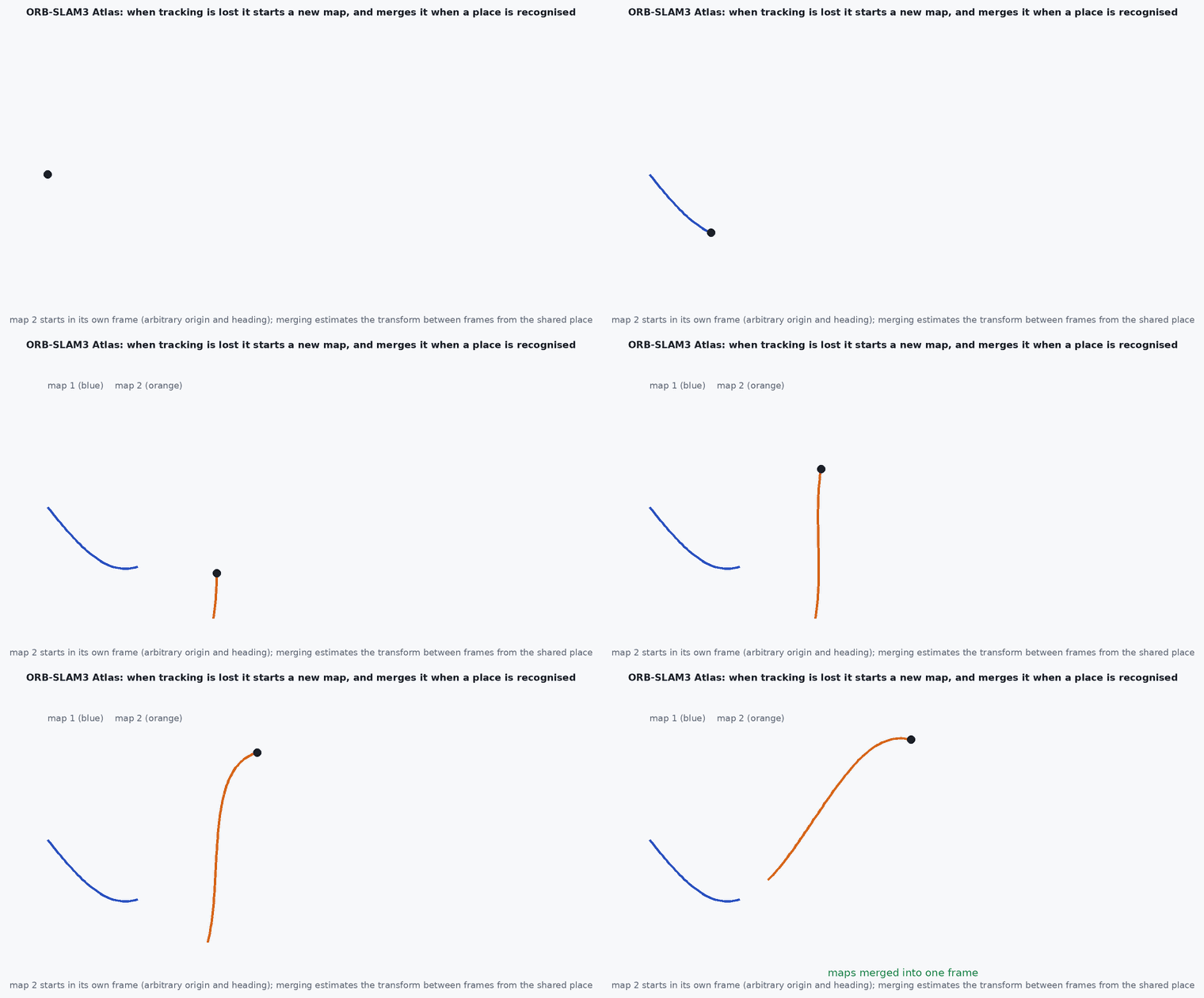
ORB-SLAM3 combines ORB features (oriented FAST keypoints with rotated BRIEF binary descriptors), a DBoW2 bag-of-words place recognition database, covisibility and essential graphs, three parallel threads (tracking, local mapping, loop closing and map merging) and an Atlas: a set of disconnected maps that are created when tracking is lost and merged when places are recognised. The visual-inertial mode adds IMU preintegration with a maximum-a-posteriori initialisation.
Engineering intuition
ORB features are cheap binary strings: matching is a Hamming distance (count of differing bits), thousands of times faster than floating-point descriptors, and they are rotation-tolerant. The price is sparsity: ORB-SLAM3 maps are sparse point clouds, good for localisation, not for planning obstacle avoidance. And as a feature-based system it needs texture; it can lose track in blur or featureless regions, which is why the Atlas exists: it starts a new map and tries to merge later, instead of dying.
For a UAV the practical question is initialisation and rate: the IMU-aided versions need initial motion, and the whole pipeline must run at the camera rate on your computer (lesson M7-T3). Check your compute budget before choosing the resolution and the number of features.
Mathematical formulation
Matching: the Hamming distance between two 256-bit descriptors and the ratio test that rejects ambiguous matches (Lowe):
Tracking minimises the reprojection error of matched map points over the camera pose (motion-only BA); local BA and global optimisation follow lesson M4-T2, with IMU preintegration factors (lesson M3-T8) and inertial initialisation as a maximum-a-posteriori estimate of scale, gravity direction and biases (Campos et al.). Loop closure: DBoW2 retrieves candidates; a similarity transformation Sim(3) (monocular) or SE(3) is verified by RANSAC and geometric checks; correction by essential-graph optimisation and global BA.
- ORB
- oriented FAST keypoint with a rotated BRIEF 256-bit descriptor.
- ratio-test threshold.
- Atlas
- set of maps with a merging mechanism.
Architecture and data flow
Run (EuRoC stereo-inertial example, as in the repository README; verify the arguments against the README of your version):
./Examples/Stereo-Inertial/stereo_inertial_euroc ./Vocabulary/ORBvoc.txt ./Examples/Stereo-Inertial/EuRoC.yaml \
    PATH_TO_EuRoC/MH01 ./Examples/Stereo-Inertial/EuRoC_TimeStamps/MH01.txt dataset-MH01_stereoi
# outputs a keyframe trajectory file (for evo) such as f_dataset-MH01_stereoi.txt and kf_dataset-MH01_stereoi.txt# excerpt of a settings file (key names as in the EuRoC examples; copy a shipped file and edit it)
Camera.type: "PinHole"
Camera1.fx: 458.654 # intrinsics from your calibration, not these example values
Camera.fps: 20
IMU.NoiseGyro: 1.7e-4 # from an Allan analysis of YOUR IMU (lesson M3-T7)
IMU.NoiseAcc: 2.0e-3
IMU.GyroWalk: 1.9393e-5
IMU.AccWalk: 3.e-3
IMU.Frequency: 200.0
ORBextractor.nFeatures: 1200Real-world UAV applications
- A visual or visual-inertial SLAM baseline for Capstone 1.
- Mapping and relocalisation in feature-rich indoor spaces.
- Comparing against VINS-Fusion and OpenVINS on the same dataset.
- Research starting point for multi-map and multi-session SLAM.
Implementation example
This runs as shown: ORB-style binary descriptor matching: 256-bit descriptors with bit-flip noise are matched by Hamming distance with a ratio test, which rejects ambiguous matches while keeping the correct ones.
import numpy as np
rng = np.random.default_rng(0)
N, bits = 300, 256
A = rng.integers(0, 2, (N, bits), dtype=np.uint8)                   # descriptors in image 1
B = A.copy(); flip = rng.random(B.shape) < 0.10; B[flip] ^= 1       # the same features in image 2 with 10% of the bits flipped
B[200:] = rng.integers(0, 2, (N - 200, bits), dtype=np.uint8)        # 100 features have no counterpart (unrelated descriptors)

def hamming_matrix(X, Y):                                            # (n, m) matrix of Hamming distances
    return (X[:, None, :] != Y[None, :, :]).sum(-1)

D = hamming_matrix(A, B); order = np.argsort(D, axis=1)
best, second = D[np.arange(N), order[:, 0]], D[np.arange(N), order[:, 1]]
accept = best / second < 0.8                                         # ratio test
correct = accept & (order[:, 0] == np.arange(N))
print(f"accepted {accept.sum()} of {N}; correct {correct.sum()}; wrong {np.sum(accept & ~correct)}; true matches kept {correct[:200].sum()} of 200; unmatched features accepted {accept[200:].sum()} of 100")
assert correct[:200].sum() > 190 and np.sum(accept & ~correct) <= 2 and accept[200:].sum() <= 2Common engineering mistakes
Default intrinsics and IMU noise from the example files
Use your own calibration and Allan results (lessons M7-T15, M3-T7).
Expecting robustness without texture
Feature-based tracking fails on blank walls and in blur.
Using the keyframe trajectory as a continuous odometry
Use the tracking pose for control, and keyframes for evaluation.
Ignoring computation
Feature count and resolution must fit the CPU budget at the camera rate.
Mixing licences
ORB-SLAM3 is GPLv3: check obligations before shipping it in a product.
Failure modes
| Failure mode | How it shows up | Likely cause |
|---|---|---|
| Tracking lost | New map created, pose resets | Fast motion, blur, low texture |
| Wrong scale (monocular) | Trajectory size wrong | No IMU or stereo, or poor initialisation |
| Bad IMU initialisation | Scale and gravity wrong | Insufficient excitation or wrong noise parameters |
| False merge | Maps joined incorrectly | Perceptual aliasing |
Debugging approach
- Check feature counts per frame and tracking state in the viewer.
- Verify calibration and IMU noise against the dataset’s documentation.
- Evaluate with evo on a dataset with ground truth.
- Profile per-thread CPU use.
Practical exercises
- Run the stereo-inertial EuRoC example and evaluate ATE with evo.
- Change the number of ORB features and record accuracy and processing rate.
- Disable the IMU on the same data and compare scale and drift.
- Explain what the Atlas does when tracking is lost.
Interview questions
Write an answer in your own words, then reveal the model answer. Nothing is sent anywhere.
Question 1
What does ORB-SLAM3 add over ORB-SLAM2?
Model answer
Visual-inertial operation with a maximum-a-posteriori initialisation, fisheye camera models, and the Atlas multi-map system that merges maps after tracking loss.
Question 2
Why are binary descriptors used?
Model answer
Hamming distance is extremely fast and the descriptors are compact, enabling real-time matching on CPUs, at the cost of lower discriminative power than floating-point descriptors.
Question 3
What is its main practical limitation for UAVs?
Model answer
It needs texture and sufficient compute, and produces sparse maps unsuitable for obstacle avoidance without another module.
References and further reading
Primary papers, official documentation and standards. Each claim above that is specific to a tool or version points here.